Provinces
Blekinge
Bohuslän
Dalarna
Dalsland
Gotland
Halland
Lappland
Närke
Skĺne
Smĺland
Södermanland
Uppland
Värmland
Västergötland
Västmanland
Öland
Östergötland
Counties
Other stuff
Home
| Dalsland: Baljĺsen - 301 m | |
|---|---|
|
Location: West of Ĺmĺl Coordinates: N 59°05.086' E 12°28.327' Exact height: 301 m Hiking: Class 1 (What's this?) Hiking distance: 2.7 km round trip Elevation gain: Approx. 100 m Map(s): Topographic: 10C SV Road map: Any road map All maps from Lantmäteriet |
We haven't been to Baljĺsen sofar and we are happy and thankful receivers, should anyone want to submit information. |
Approach:
From Ĺmĺl, drive Rt 164 towards Bengtsfors. Turn right, north, towards Prästerud, at the chuch in Edsleskog. The cabin Pettersborg is reached after about 2.5 km. Park close to the cabin.Route: A trail is leading from Pettersborg to the summit of Baljĺsen where a hut is located. After the summit, continue along the trail, east, down from the summit. Continue on the trail to the road and then back to the cabin on the road. | |
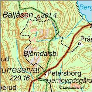 Click in the map to get a larger map!! |
|